Huellasolar

Archiviato il 21 / 04 / 2012
Archiviato...
Ottenuto
€ 365
Minimo
€ 1.245
Ottimo
€ 1.795
13 Co-finanziatori
Canale
  • Collaborando € 5

    Version pro. Free access

    Web mention + Free access to version pro. 2 weeks.

    > 03 Co-finanziatori
  • Collaborando € 10

    Free access to version pro + coupons

    Web mention + Free access to version pro. 1 month.
    sales coupon 10% in dinamic cartography (dektop viewer files) The coupon will be operative during a month since the reception and for orders over 32€ (four sectors of dinamic cartography)

    > 01 Co-finanziatori
  • Collaborando € 20

    Free access to version pro + coupons

    Web mention + Free access to version pro. 2 months.
    Sales coupon 20% in dinamic cartography (dektop viewer files) The coupon will be operative during a month since the reception and for orders over 32€ (four sectors of dinamic cartography)

    > 04 Co-finanziatori
  • Collaborando € 50

    Free access to version pro + coupons + banner

    Web mention + Free access to version pro. 5 months.
    sales coupon 30% in dinamic cartography (dektop viewer files).
    Publicity banner in web during 1 month (companies)
    The coupon will be operative during a month since the reception and for orders over 32€ (four sectors of dinamic cartography)

    > 02 Co-finanziatori
  • Collaborando € 100

    Free access to version pro + coupons + banner

    Web mention + Free access to version pro. 10 months.
    sales coupon 50% in dinamic cartography (dektop viewer files).
    Publicity banner in web during 3 months (companies)
    The coupon will be operative during a month since the reception and for orders over 32€ (four sectors of dinamic cartography)

    > 01 Co-finanziatori
  • Collaborando € 400

    Sponsor

    During a year, mention at web foot as sponsor and free access to version pro.
    Sponsors will have preference selecting new cities in order to add to the viewer data base

    > 00 Co-finanziatori

New imagen

27 | 03 | 2012
New imagen

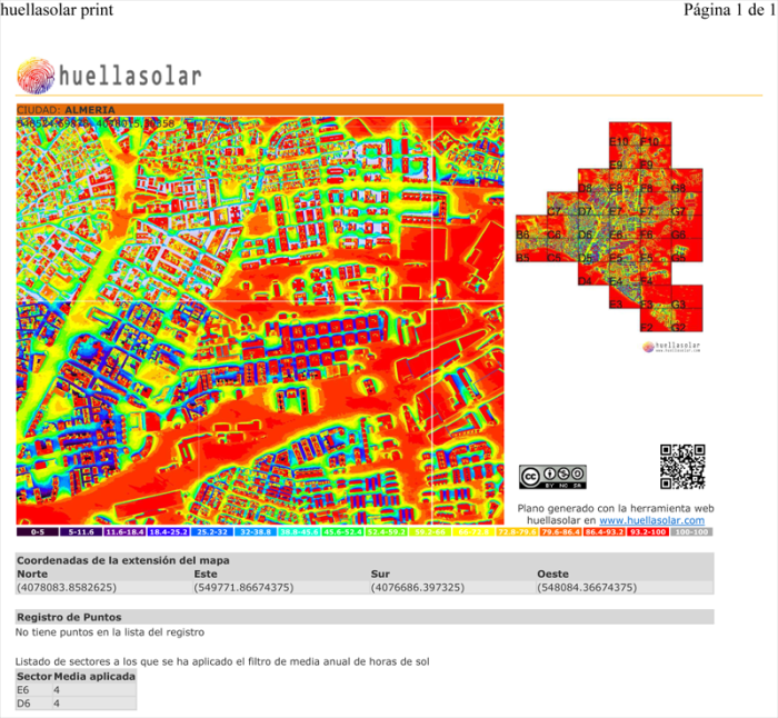
We will be able to print environment urban maps including geographical coordinates

This way the user could georeference the image.

Here you are an image that shows a preview of a print make with the tool

Commenti

Inizia sessione per lasciare un commento